Gather Around the Fire Ring Before TV, before newspapers, even before we moved into houses... the fire ring was the gathering place to tell stories
and share personal experiences.
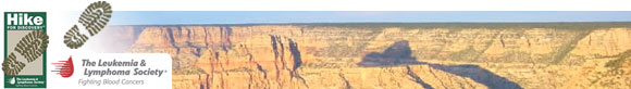
Placeholder
   Hike For Discovery
  Team In Training - HIKE
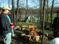
Stories
   Tall Tales
   Ghost Stories
Photography
   Nature Photography
   Random & Wonderful Photos
   Ruins Of Patapsco State Park
   Works of Art
   Your Fire Ring
Other Sites to Visit
   Friends of ENWR
   Cow Run Backpacking
   Chuck Keiper Trail Backpacking
   More Links...
Search the Fire Ring
Support theFireRing.com by shopping at amazon.com
Just shop as you normally would but start by clicking on the link above.

Friends gathered around a campfire in their fire ring
home » Hike For Discovery » HFD 2007 » Mar 24, 2007 - Sugarloaf Mountain

Meet the 2007 HFD Team

Aileen Goss
Andrea Hoffman
Brianna McMullen
Cindy Kiamko
Cindy Vogelberger
Clint Reach
Deb Donofrio
Ellen Brooks
Erin Noseworthy
 Greg Palmer
Heather Mitchell
Heidi Sowers
 Jessica Koman
Joel Shalowitz
 Kate Brotman
 Kate Greenberg
Kendra Plemmons
Kevin Pearson ‡
Kim Guercio
Kyle Bray *
Lisa Fronc *
Lauren Allen †
Olivia Darden
Patti Harden **
Paula Finkelstein
Terrill Esposito
Tracy Kight
Rosamaria Somarriba
Samuel Somarriba
** Hike Leader
* Mentor
† LLS Staff
‡ Honorary Team Member


Hike Hero - Gary

A Hike Hero in the Hike For Discovery program is a person that is currently fighting a blood cancer. The members of each group hike in honor of this individual.

The Hike Hero for the Maryland Chapter is Gary Todd. He first discovered he had enlarged lymph nodes during a visit to the hospital after having chest pains during a hike in late November 2003. In June 2005 he began feeling tired and experiencing night sweats. At first he thought he was worrying unnecessarily because of his impending retirement the next year. However, after a number of tests it was diagnosed with Stage 4, Non-Hodgkin’s spleenic lymphoma.

Gary underwent a chemotherapy treatment in six cycles over eighteen weeks and on January 1, 2006 went into remission. Unfortunately in late March of 2006 he began to feel sick again and in mid-May he began treatment with Rituxin*. He has been diagnosed with chronic lymphoma and will be taking Rituxin every ninety days for at least the next two years.

* Rituxin is an advanced and less invasive medicine that was made possible by money donated for research. It attacks only the cancerous cells and leaves healthy cells intact.


Mar 24, 2007 - 8th Training Hike
Sugarloaf Mountain

Time of Hike: 8:30 AM
Distance Hiked: 6.2 Miles
Temp During Hike: Low 51 °F   High 52 °F - Very Foggy
Elevation Change: 900 Ft

We had a much smaller crowd than usual on this hike because of the rainy weather but it was still one of the best hikes yet. The rain was mostly cleared up by the time we started our hike but a dense fog blanketed the forest cutting the site distance down to about 30 yards in any direction.

USGS Survey Marker at the top of Sugarloaf Mountain
USGS Survey Marker at the
summit of Sugarloaf Mountain

We began at the West View parking lot 300 feet from the summit and started down the side of the mountain. After reaching the bottom we hiked along the yellow trail on fairly level trails through some environmental research zones. Along one section signposts were erected telling visitors when the section of forest was clear-cut so you could see exactly how long it takes a forest to recover after it has been harvested.

Our first stop during our gradual 3 ½ mile climb back up to the top of the mountain was White Rocks overlook. I have been to the mountain many times and know that this overlook gives you a fantastic view of the surrounding farmland and the Appalachian Mountains in the distance. Today however, it was just a blank white canvas dropping away from the rocks; it looked as if we were standing at the edge of the world. Not the view I was expecting but still amazing.

The thick fog that obscured our view from the overlooks made the colors of the forest pop. The greens were bright and vibrant and the dead brown leaves on the ground had an almost red tint to them.

Only about half of the group climbed to the very summit, the other half took another trail back to the parking lot. The summit was as expected, no view because of the fog but those of use that made the climb were of the same mindset, we came this far, we might as well push the extra 300 feet up to the top.

  About Sugarloaf Mountain

Sugarloaf Mountain is a Registered Natural Landmark and is privately owned by Stronghold, Incorporated; a non-profit corporation that was organized in 1946. The mountain is open for the public’s "enjoyment and education in an appreciation of natural beauty."

Sugarloaf came by its name because its shape reminded early hunters and pioneers of the sugar loaves common in those days. Throughout its history the mountain has seen millions of visitors, the earliest known map dates back to a Swiss explorer in 1707. Later Northern and Southern forces alternated in posting lookouts at its summit during the Civil War.

Geologically, it is known as a monadnock, a mountain that remains after the erosion of the surrounding land.

For more information visit:


  Photos


Wallpaper 1024x768
Wallpaper 800x600


« Previous Entry Back To HFD 2007 Next Entry »

 this site is powered by the most energy efficient servers available © 2006 - 2024    www.theFireRing.com    &    www.sharedwebsites.net